
No products in the cart.
Outdoor Adventure
How to Check for Snow on the Trail
28
Feb
Feb
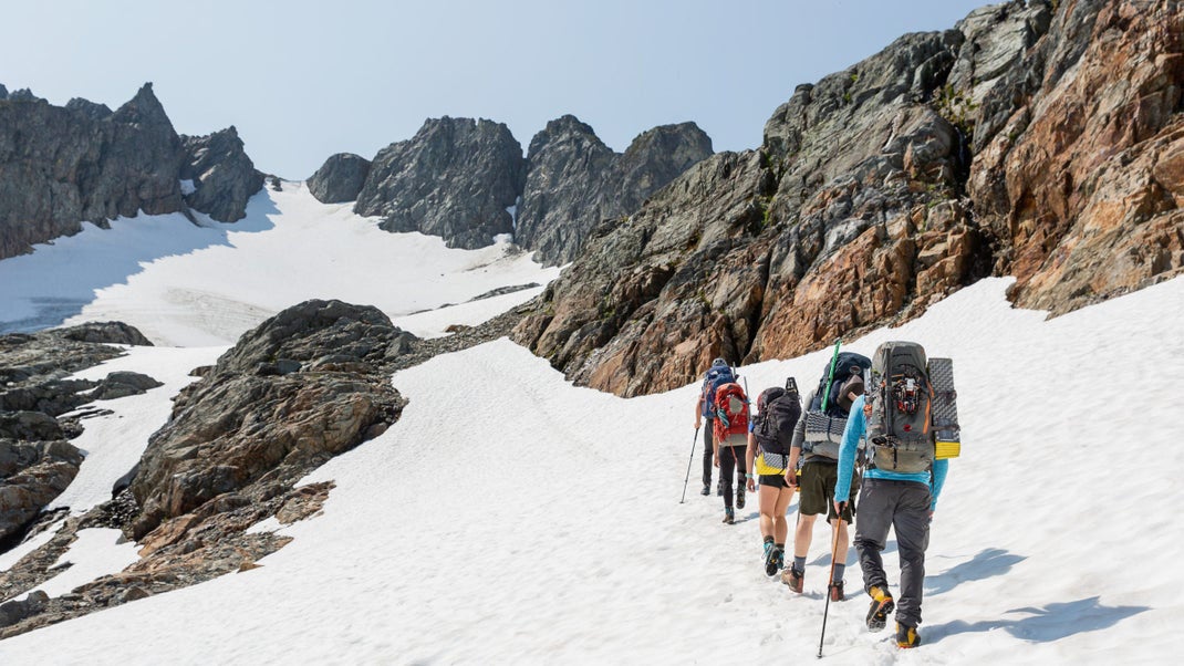
Spring is a few weeks away, and the trails will be melting out before you know it. But conditions at the parking lot do not necessarily tell you what the trail looks like up ahead. Even well into summer, snow can cling to high mountain passes. Lingering cornices and deep snowdrifts can be onerous and present obstacles.
Plus, mountain weather can turn on a dime. A warm, sunny day can quickly escalate into a freezing cold whiteout blizzard.
Thankfully, you can use Gaia GPS to help eliminate this guesswork of whether the trails will be sunny and snow-free. In this guide, you will learn how to use recent satellite imagery (FreshSat—Recent and Cloud Free layers), snow depth total estimates (Snow Depth layer), actual snowfall data (Snow Stations Daily layer), and Precipitation and Snow Forecasts to get a sense of how much snow may be on your hike or overlanding trip. You’ll also learn how to use these maps in conjunction with the best community resources to make informed decisions about where to go and what to bring.
All of the maps in this article are available with a Gaia GPS Premium Membership.
Get a Bird’s-Eye View with FreshSat–Recent & Cloud Free
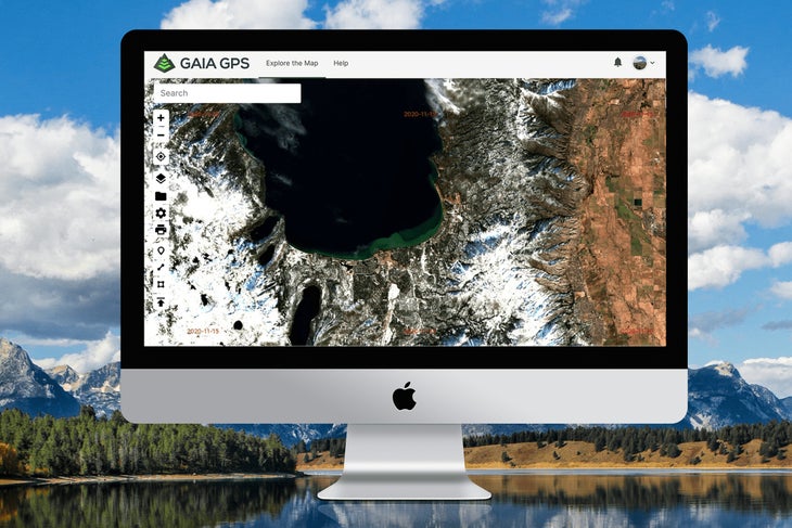
If you’re wondering whether you need crampons and an ice ax to climb your next fourteener, start by examining the FreshSat layers. These maps provide a near-in-time aerial view of conditions on the ground.
By nature of their source, these images are lower resolution than our other satellite maps. But they provide the most updated views of the terrain and conditions, which proves helpful if you want to see where snow lingers on remote mountain and forested areas. For a more crystal-clear areal view, check out the high-resolution Satellite layers.
FreshSat–Recent and FreshSat–Cloud Free both give you a snapshot of relatively up-to-date ground conditions. FreshSat–Cloud Free shows a mostly unobstructed view of the earth’s surface. FreshSat–Recent provides an even more up-to-date picture of ground conditions, but clouds may obstruct some of the view.
Both maps are updated at least every 14 days using data from Landsat-8 and Sentinel-2 government satellites. Date stamps on both FreshSat maps make it easy to identify how recently a location has been updated. Simply look at the corner of a map tile to see the date when that image was taken.
Layer these maps with your favorite base map, such as Gaia Topo, to examine the route for your trip. Start by scoping out FreshSat—Recent. If the area is obstructed by clouds, head over to FreshSat—Cloud Free. Zoom into the high points of your route, north-facing slopes, and forested areas to look for signs of snow.
Get FreshSat—Recent and FreshSat—Cloud Free.
Check Estimated Snow Depth Totals with the Snow Depth Layer
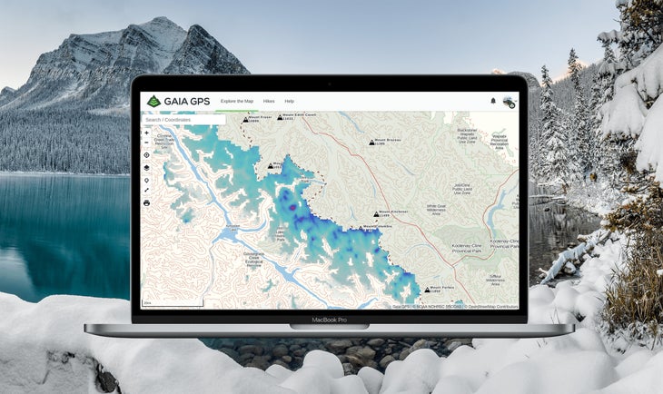
Inspired by a thru-hiker looking to track snow depths along the Pacific Crest Trail with Gaia GPS, the Snow Depth overlay gives you an estimate of snow levels covering your next route. Outdoor adventurers can examine how many centimeters of snow most likely exist in specific areas by referencing color-coded indicators of coverage.
In fact, thru-hiker Joe “Stringbean” McConaughy used this map religiously on his recent record-setting Arizona Trail “run.” Stringbean referenced this layer to get a sense of when he might encounter snow on the high-elevation sections of the trail. To do this for your next trip, just place this overlay on top of your base map. Tweak the opacity to get a picture of how much snow may be on the trail.
When referencing snow depths, remember that estimates are not based on actual observations, but product model output. However, snow depth totals are updated every 24 hours by both the National Oceanic and Atmospheric Administration and Gaia GPS. Data for snow depth values come from the NOAA National Weather Service’s National Operational Hydrologic Remote Sensing Center (NOHRSC) Snow Data Assimilation System (SNODAS).
If you’re looking to find snow totals for a storm in the western United States or Canada, reference the Snow Stations (Daily) map (see below). You can also get actual snow data by checking your local climate center or weather source. SNODAS recommends the American Association of State Climatologists, NOAA Regional Climate Services, and NOAA National Centers for Environmental Information.
Get the Snow Depth overlay.
See If It Snowed Overnight with Snow Stations (Daily)
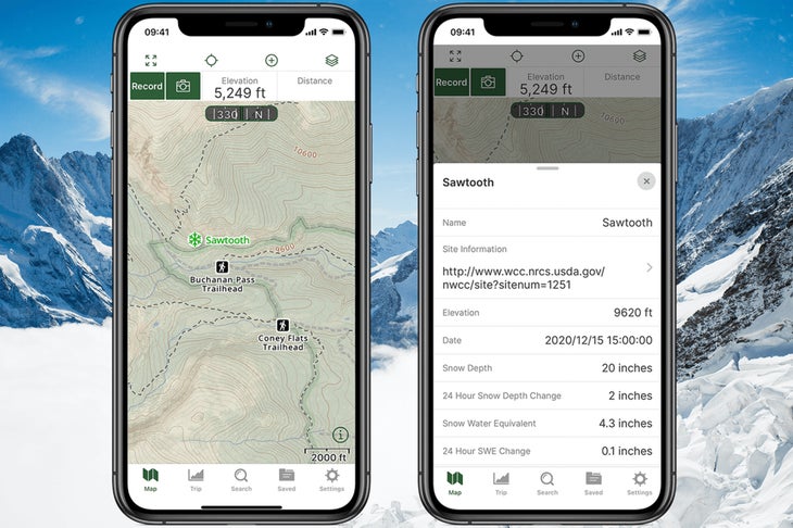
Snow chains on or off? If you’re heading out on an overlanding or backpacking trip through the mountain West, pair the Snow Depth overlay (above) with real-time snow data found in the Snow Stations (Daily) layer to get an even more accurate sense of conditions.
The Snow Stations map taps into hundreds of remote SNOTEL and Canadian weather sensors to show just how much snow fell—or melted—over the past 24 hours in mountain zones around the West. The map also provides water density readings to give you a sense of how heavy and wet this new snow may be. Readings are updated once every hour.
To use this layer, look for color-coded snowflake icons on the map. Each snowflake represents a remote weather station, and the color of the snowflake indicates how much snow has fallen or melted in the past 24-hour reporting period. Click the icon for more info.
Get the Snow Stations (Daily) map.
Check for Incoming Storms with Precipitation and Snow Forecasts
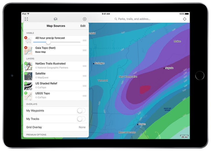
Don’t underestimate what weather may be coming your way. Check the forecast so you’re prepared and so you know when to reroute or stay home. Get a quick weather reading right in Gaia GPS with Precipitation and Snow Forecast overlays.
Three Precipitation Forecast overlays give you the 24-, 48-, and 72-hour forecasts. Each taps directly into the National Oceanic and Atmospheric Administration forecasting data. The NOAA Weather Prediction Center (WPC) researches and releases short-term forecasts twice a day, based on predictive models and satellite imagery. Its reports can forecast heavy rain, snow, and flash flooding up to seven days in advance.
Find out if that rain will turn to snow by looking at the Snow Forecast layers. Gaining a sense of whether you simply need a raincoat or would benefit from warmer layers and heftier footwear could make or break the safety and comfort of your trip. Like the Precipitation Forecast, the Snow Forecast comes in 24-, 48-, and 72-hour options.
Choose the best day to head out on the trail by referencing the right weather overlay. Heading out for a weekend backpacking trip? Check out the 72- or 48-hour forecasts to get a view of overall precipitation. Use the 24-hour forecast to get a quick and accurate prediction for the weather today and tomorrow. You must be connected to the internet to view the Precipitation and Snow Forecast maps.
Get the 24-hour, 48-hour, and 72-hour precipitation forecasts. And get the 24-hour, 48-hour, and 72-hour snow forecasts.
Watch: Discover If the Trails Are Melted Out
Talk to People
Maps provide invaluable tools—but they don’t replace firsthand beta. Talk to people who have recently visited the area to get the most up-to-date trip reports possible. In addition to your friends and local community, check out Facebook groups, subreddits for the area, local trail organizations and park websites, and Backpacking Light forums. And, of course, there’s the good old-fashioned telephone—you can use it to call the ranger’s station to get the latest trail conditions report.
For example, mountain athlete Kyle Richardson has summited Longs Peak (Neníisótoyóú’u) in Rocky Mountain National Park 52 times, during all seasons. He even set a speed record on it last summer. Despite his intimate familiarity with the fourteener, he never presumes to know what the mountain may have in store that day. When deciding whether to attempt Longs (and what gear to bring), Richardson checks the Rocky Mountain National Park webcam, mountain-forecast.com, and 14ers.com for recent trip reports.
Look at the photos other visitors have posted. In addition to forums, you can find recent photos by checking relevant hashtags on Instagram and Twitter. Don’t be afraid to ask questions. And once you’ve gone on your trip, do the community a favor and drop a line on the conditions you encountered.
A Note on Safety
You can use these resources and maps as a planning tool to help you pack, plan your route, and be ready for the weather and trail conditions ahead. Know the terrain and alternate routes ahead of time. Plan for inclement weather, even if none appears in the forecast. Gaia GPS provides map layers to help prepare, but making wise decisions remains with you.
Source link