
No products in the cart.
Fitness Tips
Map Shows Which States Could See the Most Dangerous Weather Over the Next Two Weeks

10
Aug
Aug
If you’re looking at the weather forecast for the next couple of weeks, temperatures won’t be the only thing worth watching.
A new outlook from NOAA’s Climate Prediction Center is highlighting several potential weather hazards across the U.S., including a prolonged period of extreme heat in parts of the South and the possibility of heavy precipitation farther east.
The latest outlook covers August 17 through August 23, giving residents in several regions an early look at where potentially dangerous conditions could develop.
The South Could Face a Prolonged Heat Event
The most significant concern on NOAA’s latest map is across portions of the Southern Plains and Lower Mississippi Valley.
According to the Climate Prediction Center, a strong area of high pressure could remain in place across the south-central and southeastern U.S. into the second week of the forecast period.
That setup could produce a long-duration, significant heat event, with NOAA designating a high risk for extreme heat across portions of the Southern Plains and Lower Mississippi Valley.
For people living in the region, that could mean more than just a few unusually hot afternoons. The concern is that the heat could persist over an extended period, increasing the potential impact on people, pets, outdoor workers and anyone without reliable access to air conditioning.
The Heat Could Also Bring Another Risk
NOAA is also watching conditions that could contribute to rapidly developing drought.
The agency says antecedent dryness, combined with little precipitation expected over the next two weeks, supports a risk of rapid-onset drought across portions of the Southern and Central Plains and Lower Mississippi Valley.
That means the same general region facing the heat could also see worsening moisture conditions if rainfall remains limited.
The outlook isn’t predicting that every location within the highlighted region will experience the same conditions. Instead, the map identifies areas where the probability of certain hazards is elevated.
Another Part of the Country Could See Heavy Rain
The potential hazards aren’t limited to the South. NOAA says a broad area of low pressure over eastern Canada could help create enhanced northwesterly flow, with moisture and frontal activity moving from the Four Corners toward the Midwest and Eastern Seaboard.
That could bring periodic heavy precipitation early in the second week of the outlook.
In other words, while some areas are watching for prolonged heat and dry conditions, other parts of the country could be dealing with the opposite problem: too much rain arriving in a relatively short period.
NOAA.gov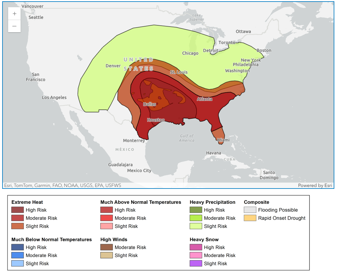
What the Map Means for the Rest of August
The latest outlook is a reminder that late summer could look very different depending on where you live.
The Southern Plains and Lower Mississippi Valley are the areas NOAA is most concerned about for prolonged extreme heat, while areas stretching from the Four Corners through portions of the Midwest and toward the Eastern Seaboard could see periods of heavier precipitation.
And because the outlook extends beyond the normal seven-day forecast window, it gives people more time to keep an eye on developing conditions.
The CPC will continue updating its outlooks as new weather data and forecast guidance become available.
Most importantly, these maps represent probabilities rather than guarantees. NOAA notes that the hazards outlook is intended to provide advance notice of potentially high-impact weather and climate hazards, so conditions can change as the forecast period gets closer.
Source link
