
No products in the cart.
Outdoor Adventure
Want to Road Trip Across the American Southwest? This Is How We’d Do It.
02
Nov
Nov
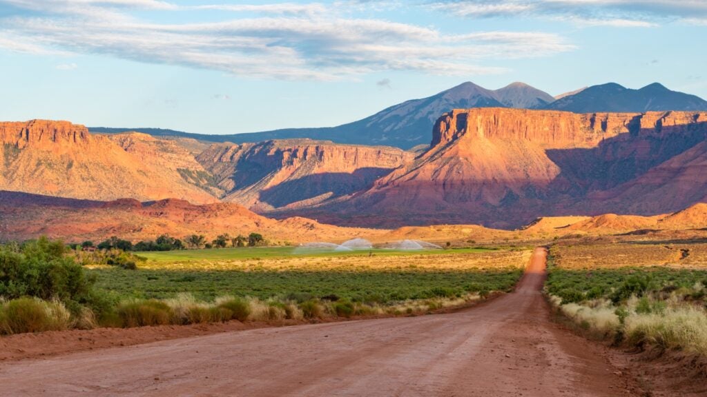
Edward Abbey, who immortalized the Southwest in his writing, would be turning over in his grave in Cabeza Prieta Wilderness west of Tucson, Arizona, if he knew that Arches National Park had to temporarily close its gates in mid-October because capacity was maxed out. The famous monkey wrencher saved a special venomous wrath for the kind of tourist who drove from one viewpoint to the next only to snap a photo and move on.
But Abbey, who was a ranger at Arches for two summers in the 1950s (when it was still a monument), also understood that there’s no better region than the Southwest, a place of mind-bending geology, impossibly living fauna, ferocious wide-open spaces, sublime light, and millennia of human history, to clear the mind and make peace with the soul.
I lived in Santa Fe, New Mexico, for 18 years, love the Southwest, and believe everyone can benefit from the solace and adventure these majestic landscapes provide. We all, however, need to grapple with how to responsibly recreate within them. If you choose to wander, this wide-ranging Southwestern road trip starts and ends in Tucson, and hits icons and off-the-beaten-path places, providing an itinerary to the best of the region. It’s ridiculous how much jaw-dropping splendor there is on this trip.
In the words of Abbey: “for god sake folks…take off those fucking sunglasses and unpeel both eyeballs, look around; throw away those goddamn idiotic cameras…stand up straight like men! Like women! Like human beings! And walk—walk—walk upon our sweet and blessed land!”
Might we politely add: leave no trace, BYO water, and respect those who came before you.
1. Route: Tucson, Arizona to Patagonia, Arizona
Distance: 64.8 miles
Your Base Camp: Patagonia
Patagonia, a no-frills mining and ranching town 20 miles north of the Mexican border, cropped up in the middle of Pima, Tohono O’odham, and Apache territory in the late 19th century. It has been a beloved destination for birders almost ever since.
Adventures in Patagonia
- Hikers and trail runners have easy access to the summits of 9,456-foot Mount Wrightson and the historical fire lookout station at the top of 6,373-foot Red Mountain.
- What has more recently put Patagonia on the map is its mountain bike and gravel cycling, with 30 miles of new singletrack right from downtown on the Temporal Gulch Trail and endless miles of dirt roads in the San Rafael Valley. Take note: the Spirit World 100 gravel road race takes place the first weekend of November and sells out fast.
- Visit the Paton Center for Hummingbirds outside of town. They have documented 247 bird species.
Where to Stay
The Gravel House is built for small groups of cyclists, with a straw-bale house that sleeps six and a wood-framed studio that sleeps two. Both have kitchens and share outdoor space to wrench on bikes or celebrate post-ride with a cocktail.
Where to Eat and Drink
- Chef Hilda at the Patagonia Lumber Company serves a delicious menu, filled with Sonoran specialties like fresh tamales, carne adovada tacos, and barbacoa.
- The new Queen of Cups restaurant and winery offers fresh pasta dishes and three house-made wines on the menu.
The Best Detour
Tucson’s Arizona-Sonora Desert Museum is a must-stop destination for travelers who want to learn more about the fragile yet resilient ecosystem they are traveling through. A highlight includes daily Raptor Free Flights, where birds only native to the Sonoran Desert, like the Chihuahuan Raven, Harris’s Hawk, and Great Horned Owl, fly free while an expert describes their attributes, habitats, and behaviors.
2. Route: Patagonia, Arizona to Big Bend National Park, Texas
Distance: 624 miles
Your Base Camp: Terlingua, Texas
It might take you a few days to get to Terlingua because there are a lot of fun detours along the way (see below). But the wait is worth it. This town, once 2,000 inhabitants strong and rich with cinnabar from which miners extracted mercury in the late 19th century, now stands by its claim as one of the most popular ghost towns in Texas, with 110 residents.
Adventures in Terlingua, Texas
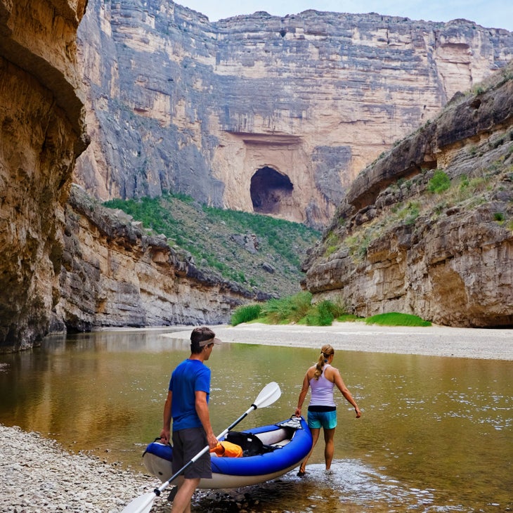
- Sitting six miles west of the entrance of Big Bend National Park, Terlingua offers easy access to all the 801,163-acre park has to offer, including rafting or kayaking the Rio Grande River, hiking the Chisos Mountains, or road cycling its low-traffic paved highways.
- Just west of Terlingua is the storied mountain biking in Big Bend Ranch State Park, including the challenging 59-mile Fresno-Sauceda IMBA Epic route known for long, steep, technical, and rocky climbs and descents. Heavy rains have washed out much of the park’s trails, so check in with Desert Sports, whose owners Mike Long and Jim Carrico (a former superintendent of Big Bend) provide a wealth of knowledge about where and where not to go, and offer shuttles, guides, and equipment.
Where to Stay
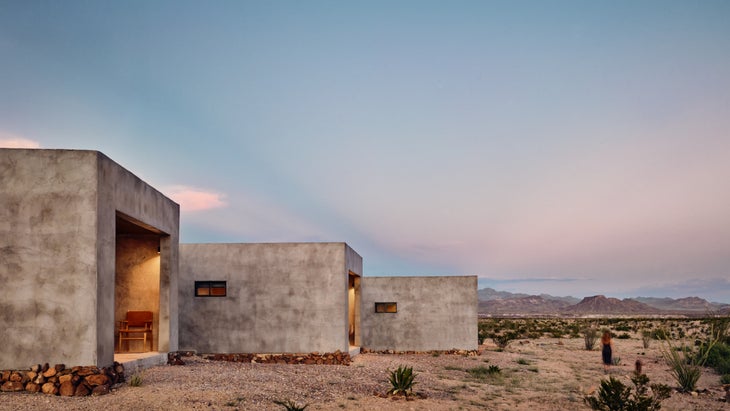
Willow House founder Lauren Werner settled in the Chihuahuan desert of far west Texas to create an austere, cool, and comforting oasis for artists and others longing for open spaces and an unbridled night sky. Twelve private casitas that look like modernist concrete cubes all have stunning views of the Chisos Mountains. Guests can bring their own provisions to grill outside or cook in the main house’s gourmet kitchen, then retreat to the privacy of their own front porch to cozy up under an Alpaca throw and gaze up to the heavens.
Where to Eat and Drink
Stop at the Starlight Theatre Restaurant and Saloon, sit on the front porch and sip a beer, then head inside for tequila-marinated Texas quail, a Scorpion margarita, and a rollicking night of live music.
The Best Detour
- Chiricahua National Monument 131 miles northeast of Patagonia. Stretch your legs on the 7.3-mile-long Heart of Rocks Loop that surpasses the most unusual formations in the monument, including the aptly named Pinnacle Balanced Rock that looks like it might topple over any second.
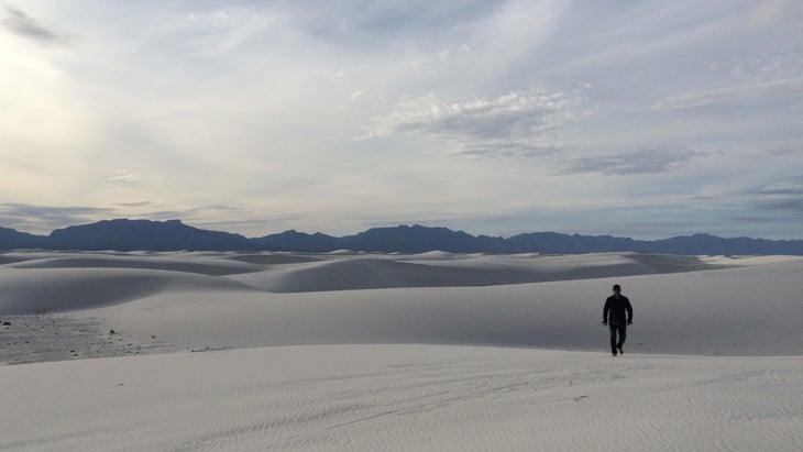
- Three hundred eighty-two miles east of Chiricahau is New Mexico’s White Sands National Park, home of the world’s largest gypsum sand dunes. Take a ranger-guided hike to Lake Lucero to understand how the dunes are formed. Bring a tent and grab a backcountry permit at the visitor’s center (available the day of camping only) to sleep among the dunes, preferably under a full moon.
3. Route: Big Bend National Park, Texas, to Taos, New Mexico
Distance: 570 miles
Your Base Camp: Taos, New Mexico
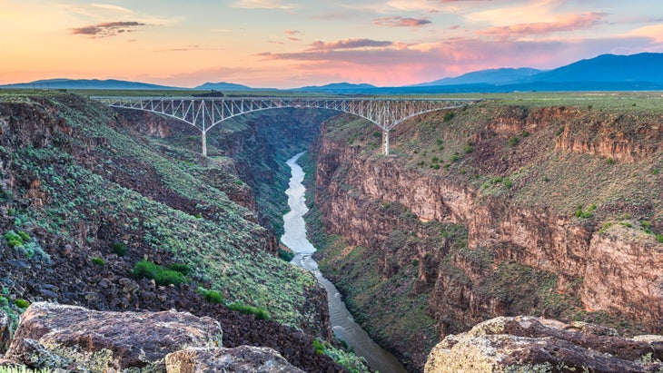
I’ve spent many days hiking, mountain biking, and skiing in the stunning land around Taos. To the west of the small town, the Wild and Scenic Rio Grande River has sliced like a hot knife through layers of volcanic basalt and ash, 800 feet below the Rio Grande Rift Valley. To the east, the Sangre de Cristo mountains top out at 13,161-foot Wheeler Peak, the tallest point in New Mexico. In the middle sits a town of roughly 6,000 artists, cowboys, skiers, free spirits, and others. By far the most established are the Puebloan people, who have continuously lived here for more than 1,000 years.
Adventures in Taos, New Mexico
- Respectfully visit the UNESCO World Heritage site of Taos Pueblo, the main part of which was constructed between 1000 and 1450 A.D, centuries before the first Spanish explorers arrived in 1540 in search of the fabled golden cities of Cibola. The visit will help contextualize other historical gems in town like the Kit Carson House and Museum, which the famed trapper, frontiersman, and explorer bought in 1843.
- Eighteen miles northeast and 2,200 feet above Taos is the base of Taos Ski Valley, one of the steepest alpine resorts in the country. In the summer it’s an excellent base from which to launch a hiking expedition to the top of Wheeler Peak via the 8.5-mile out and back trail that passes Williams Lake. Power down the peak before 4 P.M. to polish off a 32-ounce stein of German beer and a plate of Sauerbraten Wienerschnitzel at the iconic Bavarian Restaurant back at the base.
- The 12.7-mile loop trail at Horsethief Mesa northwest of town is a good lower-elevation option for intermediate mountain bikers.
- For more of a challenge, and time commitment, shuttle or hitchhike east on U.S. 64 to Valle Escondido for the start of the South Boundary Trail, a 30-mile singletrack challenge that tops out at 10,729 feet. Some of its gnarliest rocky descents are at the very end.
- For experienced whitewater paddlers and rafters who want a thrill, the Taos Box offers class IV rapids at the depths of the 800-foot Rio Grande Gorge. Lower down the river is the Racecourse, a mellower section of Class II-III rapids, perfect for a half-day journey for kids as young as five. New Mexico River Adventures offers half-day, full-day, or overnight options on both sections of the Rio Grande and other rivers nearby.
Where to Stay
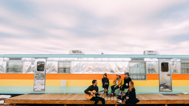
Kick in the nostalgia in one of the 21 vintage trailer units dating between 1951 and 1972 at Hotel Luna Mystica a couple of miles north of Taos in El Prado on the wide open Hondo mesa. Across the road are the ever-flowing tap beers at Taos Mesa Brewing; above is a blanket of stars.
Five minutes west of downtown Casa Gallina is a cluster of five classic and colorful Southwest casitas sandwiched between verdant gardens fed by two acequias, part of the town’s historic agricultural district. Each casita has a kitchen in which guests can cook freshly picked vegetables and eggs gathered daily from the 30 to 40 free-range hens, owner Richard Spera’s “girls,” that roam the property.
Where to Eat and Drink
- Manzanita Market in downtown Taos is the more accessible little sister to the Love Apple restaurant, the latter being one of the most coveted reservations in the region. In addition to deliciously healthy meals, Manzanita serves up small batches of ice cream made from local organic cream, eggs, seasonal fruits, and handmade caramel.
- The Love Apple is housed in a 19th century chapel and serves northern New Mexico specialties, like red chile enchiladas made with local, organic ingredients. I try to eat here whenever I’m in Taos. Make a reservation for sure.
- Meanwhile, Medley, so named for its D.C. and L.A. expat chefs Wilks and Colleen Medley, offers a craft cocktail menu that is as mouth watering as the tantalizing comfort food they serve.
The Best Detour
Carlsbad Caverns National Park, 235 miles north of Big Bend, is worth the time for a visit, especially when you contemplate how long it took to create the 120 known caves. The process began 265 million years ago with the calcareous sponges, algae, and lime-rich mud that formed the underwater reef in the Permian Sea that once covered this region. The largest cave open to the public is Carlsbad Cavern, which stretches 30 miles long and opens into the 8.2-acre Big Room, the biggest cave chamber by volume in North America.
4. Route: Taos, New Mexico to Black Canyon of the Gunnison National Park, Colorado
Distance: 271 miles
Your Base Camp: Gunnison, Colorado
This four-hour drive pushes the northern limits of what is technically considered the Southwest. There’s a more well-trodden southern Colorado route from Taos that shoots through Durango, and that’s the best bet to take if you’re traveling in winter when the Gunnison area can be hampered by heavy snow and seasonal closings.
Adventures in Gunnison, Colorado
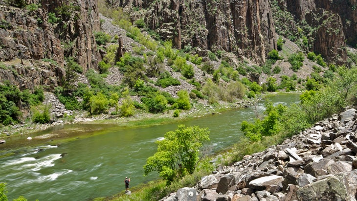
- In the summer, the Black Canyon of the Gunnison National Park 61 miles west of the town of Gunnison is a must-see. The 48-mile-long, 2,722-foot-deep canyon is not the longest or deepest in North America by a long shot. But its two-billion-year-old vertical black gneiss walls have been almost inaccessible for millennia, even to the Ute, the first inhabitants of this region.
- Most of the national park’s annual 308,000 visitors (for comparison, Grand Canyon National Park receives almost five million annual visitors) choose to view it from its north or south rims. The six-mile-long unpaved North Rim Road has six overlooks, some of which offer the best views to the canyon’s near-vertical walls. Those who choose to can hike down on one of six wilderness trails—three on the north rim and three on the south rim—all of which require a permit obtained from the visitor’s center on the south rim.
- Expect routes into the canyon that lack stairs and switchbacks and descend 2,000 feet in the course of a mile. It’s essential to come prepared to tackle these tough routes with water, food, and the appropriate clothing for changeable weather. The payoff is some of the best trout fishing in the state on the Gunnison River. All rainbows are catch and release and the brown trout daily limit is four.
- Easier to access and closer to Gunnison is Curecanti National Recreation Area. In addition to containing 19 miles of the Black Canyon, it also has four reservoirs, including Blue Mesa, the state’s largest body of freshwater. All this liquid makes for a utopian setting for standup paddlers, kayakers, and kitesurfers. Lake Fork Marina, 26 miles west of Gunnison on Blue Mesa Reservoir, rents canoes, kayaks, and SUPs. The 3.5-mile round-trip Dillon Pinnacles hike, on the northside of Blue Mesa Reservoir, is great for kids and trail running and offers open views of the aquamarine water and its namesake 600-foot volcanic formations.
- Hartman Rocks Recreation Area three miles south of Gunnison has 45 miles of singletrack, 45 miles of dirt roads, and countless crags—a haven for mountain bikers, gravel cyclists, and rock climbers. Three trails, Sea of Sage, Lost Dog, and Broken Shovel, are wide enough for hand cyclists. No place in town offers rental bikes—leftover inventory and staffing shortages from the pandemic—but Tomichi Cycles can tune your bike and point you toward their favorite trails.
Where to Stay
Thirteen miles north of Gunnison, Campfire Ranch on the Taylor River offers ten well maintained, walk-in, tent-only campsites, each with tent pads, a picnic table, and fire ring. Nearby is free firewood, vault toilets, and a potable well water pump. To make the sites more inclusive to all, the ranch also offers on-site rental and demo camping gear, plus a 50-percent discount to actively enrolled college students.
Where to Eat and Drink
- 1880s Tapas & Spirits in Gunnison serves an impressively authentic menu of the Spanish small plates. Pair “octopus a la plancha” with an eclectic array of cocktails.
- An espresso from Tributary Coffee Roasters a block down the road will get you going the next morning.
The Best Detour
Great Sand Dunes National Park and Preserve is roughly 100 miles north of Taos. The tallest sand dunes in North America rise 750 feet into the sky under the shadow of the surrounding snow-capped Rockies. The park has seven backcountry campsites along the 11-mile-long Sand Ramp Trail, an ideal spot to stretch your legs and then watch the Milky Way shimmer in the night sky.
5. Route: Black Canyon of the Gunnison National Park, Colorado to Escalante, Utah
Distance: 339 miles
Your Base Camp: Escalante, Utah
Escalante is situated in the midst of everything: Bryce Canyon National Park, Grand Staircase Escalante National Monument, and lesser known state parks like Kodachrome Basin and Escalante Petrified Forest. A few hours farther are Zion and Capitol Reef National Parks. And between all of that bounty are unsung slot canyons closer to town and the nearby lakes, rivers, and trails within Dixie National Forest that covers the Aquarius Plateau, the highest timbered plateau in North America, topping out at 11,328 feet.
Adventures in Escalante, Utah
- The options seem endless in every direction, but a good shakedown hike is to Lower Calf Creek Falls, a six-mile round-trip effort that starts at the campground in the Calf Creek Recreational Area 15 miles east of Escalante. When the water is flowing, it cascades 130 feet over streaked Navajo Sandstone into a deep, refreshing pool.
- Escalante Outfitters offers guided fly-fishing to under-the-radar lakes and streams on the Plateau and a fascinating and low-key natural history hike of Grand Staircase Escalante National Monument that gives an excellent overview of the ecology, geology, paleontology, zoology, and archaeology of the region.
- Cyclists can stop in at Escalante Cyclery to rent a dual-suspension or e-mountain bike for the day, hire a shuttle to a trailhead, or sign on for a multi-day road cycling tour to Capitol Reef National Park.
Where to Stay
- Don’t be fooled by the “yurt” in Escalante Yurts, a mile and a half north of town. These seven year-round structures are luxurious, with en-suite bathrooms, air conditioning, heating, hot breakfast burritos, or other hearty eats brought to your door every morning, and a night sky that never seems to end.
- A few miles west of town off Highway 12s Yonder Escalante has Airstreams, tiny cabins, and plenty of space to park your own RV, car, tent, or camper. Communal areas include a luxurious spa-like bathhouse with heavenly hot private indoor-outdoor showers, an oversize pool, and a nightly movie at the drive-in.
Where to Eat and Drink
A Bighorn Pizza (Kalamata tapenade, prosciutto, ham, goat cheese & slow roasted tomato) accompanied by any leafy salad enjoyed while people watching from the front patio at Escalante Outfitters is the ideal way to refuel and re-enter after an epic outdoor adventure. Inside the store, stock up on any last-minute essentials for hiking or camping.
The Best Detour
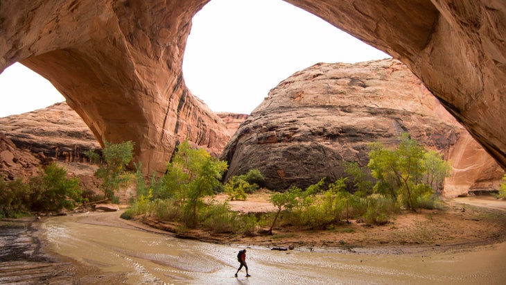
You could add 57 miles to the journey and spend a week meandering through the 2,000-plus formations of Arches National Park. But we recommend giving beloved Arches and nearby Moab a rest and instead head north to I-70 to hit the trifecta of mountain bike trail networks between Palisade, Grand Junction, and Fruita, Colorado, which range from a breezy four-mile beginner Rustler’s Loop to the 12.1-mile rocky and technical Lunch Loop Trails to the epic 143-mile-long Kokopelli trail that will eventually take you southeast back toward Moab.
6. Route: Escalante, Utah to Tucson, Arizona
Distance: 581 miles
Your Base Camp: Cottonwood, Arizona
Northern Arizona, with its Grand Canyon views, the mountain trails of Flagstaff, and the calming red rocks of Sedona, is anything but a secret. It’s especially imperative to tread lightly through this place that is the traditional home of at least 11 federally recognized nations. One way to disperse the tourism load is to stay 19 miles southwest of Sedona in the Verde Valley town of Cottonwood, so named for the willowy trees that line the Verde River.
Adventures in Cottonwood, Arizona
While it lacks the mystery and awe of Sedona’s red rocks, Cottonwood has its own allure, with the craggy peaks of the Mingus mountains to the west, hiking and cross country mountain biking on the 15-mile Lime Kiln trail that links Dead Horse Ranch State Park to Sedona’s Red Rock State Park to the east; and exciting energy in the historic Old Town, which include multiple breweries, wine-tasting rooms, and restaurants.
Where to Stay
The charming one-bedroom, one bath Casita Blanca at San Juan Ranch Airbnb in the heart of the Verde Valley, has desert and mountain views, a gas stove for chilly evenings, and is only a 15-minute drive to Old Town.
Where to Eat and Drink
Colt Grill BBQ & Spirits on North Main Street in Old Town is legendary for its in-house smoked meats. There’s only one way to eat the delightfully messy pulled pork sandwich accompanied by a side of butter garlic fries: devour it. Expect elbow to elbow dining. Merkin Vineyards, which has a tasting room on North Main Street, sources 100 percent of their grapes from local Arizona growers.
The Best Detour
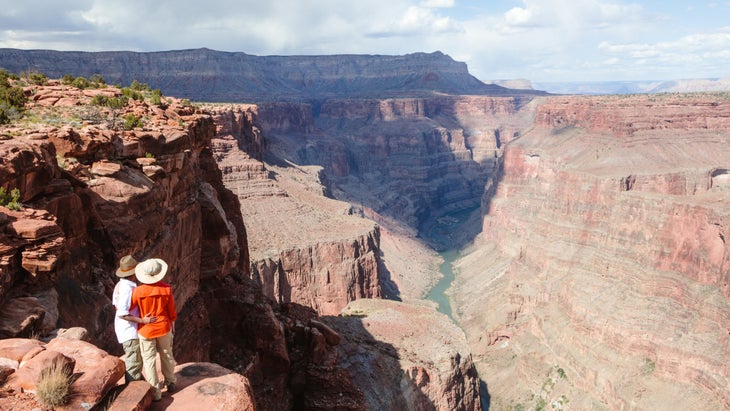
Of the five million annual visitors at Grand Canyon National Park, only ten percent take the road less traveled to the north rim, the traditional homeland of the Southern Paiute. The North Rim Campground sits at 8,200 feet and is open from May 15 to October 15.
The payoff for this 80-mile out-and-back detour on dirt roads is unparalleled views and unpeopled access to the 28-mile-long round-trip North Kaibab trail, the only maintained trail into the canyon from the North Rim. To see the most spectacular sunrise of your life, get up before dawn and hike 4.2 miles into Cape Final. The trailhead is off the Cape Royal Road.
Contributing editor Stephanie Pearson lived in Santa Fe, New Mexico, for 18 years, has written numerous travel stories for Outside, and is the author of the recent book 100 Great American Parks.
Source link